So I was intrigued when I read this article about North Carolina incorporating ArcGIS into K-12 education. The article reads like a press release hailing the advance of GIS and the need for children to learn about spatial analysis. It is a cool license, considering ESRI charges about $1,400 bucks for one license, and a yearly $400 after that. With this scheme, NC schools and their after school club counter parts (things like 4H and the Scouts), will get free access.
I get pessimistic though. Maybe it is my age but I remember Oregon Trail and limited access early internet taking up the majority of the computer lab's computing resources. If anything, I would be a little scared if my job was in the mapping cave (seriously, these rooms exist, they move the cartographers as far underground as possible to avoid them having to interact with anyone). Now children could be coming out of high school with more GIS experience than the senior cartographer, and they work for minimum wage.
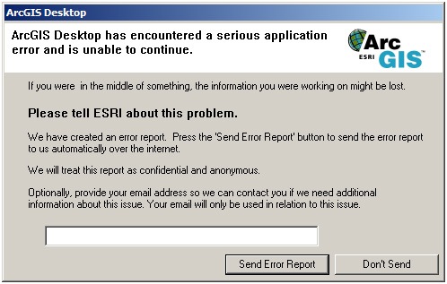
Personally, I would prefer a GIS program that actually functioned easily and was accessible by everyone. This isn't really about the main functions that GIS can perform, those really haven't changed. What has occurred is a program has been developed that every six months changes so much that no knows how to use it without going back to ESRI and spending money to figure out where the layout button has been moved to. Or even better, you think you have a program that actually works for something but for some reason this image pops up right when you get your data the way you want:
GIS in schools, Sure why not. ArcGIS in schools, stop making people slaves to ESRI! I am seriously thinking about using QGIS, and hey guess what, it is always free. Maybe VA should jump on the freeware bandwagon? Just a thought.
Sources in order of use:
http://www.esri.com/software/arcgis/index.html
http://www.esri.com/
http://www.gisdoctor.com/site/2011/02/24/does-everybody-hate-arcgis-10/
http://spatialnews.geocomm.com/dailynews/2012/mar/16/news2.html
http://downloads2.esri.com/blogs/images/support_1971.jpg
http://www.qgis.org/
You certainly have a unique perspective on the GIS craze that has been sweeping the nation, and I must say that it is a very refreshing one; we need more people advocating a cautious approach to new technologies and their applications. I suppose any time there is a new program that is as popular as GIS, there will always be those looking for anyway to make a quick buck off of it. To be honest, this whole thing looks like a big a PR move by ESRI, and I agree that there should be an alternative. The question is, how do we create this independent GIS program for public schools? It would obviously be a huge undertaking, and an expensive one too. How do we do it with public education's continuously shrinking budget?
ReplyDeleteI agree that there should be ways to use GIS that are less complicated and that ArcGIS isn't for everyone. On the other and, I think it's also very important for professionals to have the tools that ESRI's software provides. I am working with ArcMap every day at my current job and I am able to use it efficiently with limited training. I find the help section to be very helpful and I can always find an answer by Googling it. Plus ArcGIS 10 has incorporated a lot of changes that make it more user-friendly. Of course the high price tag does not make it accessible to everyone, thats where other GIS platforms come in.
ReplyDeleteI also liked the article you mentioned about GIS in K-12 education. I actually just came across something on the Chesapeake Public Schools website about a GIS class for students in grades 9-12. The class teaches them how to solve problems using spatial analysis. I'd never seen something like that before but I think its a really good idea.
I am of the opinion that eventually Google will make a product that is free for the user and doesn't crash every 30 mins. When that happens Jack Dangermond is going to be out of a job.
ReplyDeleteI agree that (and assume that) ESRI is rethinking it's business model. Hopefully products like QGIS will gain popularity. One way to do this is for schools to make a commitment to open source software products.
ReplyDelete